THE SEARCH FOR OSWESTRY TOWN WALL
by DERRICK PRATT
IV. EXCAVATION REPORTS (to 1980)
Between October 1979 and September 1980, as opportunity offered, members of the B.C.A.G. cut six exploratory trenches at intervals along conjectural line of Oswestry town wall in Cae Glas Park and Welsh Walls. That they were able to adhere generally to the excavation strategy already outlined was due in no small measure to the generous co-operation and active encouragement on the part of Oswestry Borough Council, especially Mr. W.J. Philips, Chief Technical Officer, and Mr. and Mrs G. Jones, of Knockin, owners of the then 'Walford Café', now the 'Walford Pine Shop', Willow Street. The early excavations were carried out under the direction of Mike Edwards, Manchester University, whose reports, already circulated in the B.C.A.G. 'Newsletter', are collated below ( *84 ). Plans and drawings are based on the work of Mr. George Holmes, B.C.A.G. honorary surveyor.


CAE GLAS PARK I
On 26 - 27 October and 3 - 4 November 1979 excavations were carried out near the tennis courts in Cae Glas Park (SJ 28872962), on the suspected line of Oswestry town wall between the New Gate and Willow Gate. East of, and immediately adjacent to, an existing park wall a trench (8.5m x 1.5m wide) was cut across a lawned area and flower beds. The first weekend was spent removing earth and rubble that had obviously been brought into the park on various occasions for landscaping. Amongst this overburden, and therefore irrelevant for dating purposes, was found a silver coin of Edward I (1272-1307), which, from its thin profile and poor surface condition, was adjudged to be a contemporary forgery. By the end of the first week a cobbled area had been reached, extending a quarter of the way along the line of the trench.
The following week-end, after recording, this cobbled surface was stripped away to reveal a destruction layer containing a great quantity of stone, bone and pottery of a medieval date. In the north-western corner of the trench, hard up against the present park wall, were found a number of large, dressed stones that must have tumbled from a wall of considerable size. (A fragment of town wall discovered in 1973 was 2.5m wide). Associated with these stones was a small area of worn paving slabs lying on the natural boulder clay. A pit, possibly oval-shaped was only partially excavated, but it, too, had a large dressed stone in the bottom, implying that it was open and contemporary with the tumble from the wall. The features of this particular trench suggested that the medieval wall possibly underlies the park wall and adjacent tarmaced surface.
Some 514 pieces of bone, teeth and tusk were recovered from the trench, distributed stratigraphically as follows: landscaping material - layer 1, 54 bones, 14 -teeth; layer 2, 14 bones, 45 teeth; layer 3, 10 bones; layer 4 (destruction layer, much disturbed), 308 bones; layer 5, (medieval, undisturbed), 69 bones. The material was largely fragmentary, and was not subject to detailed pathological examination. Less than a quarter of the fragments could be positively identified as emanating from cow, ?bull, sheep, ?goat, pig, dog and birds - duck, goose and domestic fowl. The unidentifiable fragments were divided where possible into 'large' (Bos, Equus and Ovicaprid) and 'small' (Canis) mammals, and this demonstrated the predominance of large animals. Possible butchering marks were visible on several fragments.
The trench also threw up an hetrogenous collection of pottery. In layers 2 and 3 particularly the pottery ranged over a wide spectrum, late17th to 20th century. Material included china; porcelain; cream-ware; stoneware, glazed and unglazed; Staffordshire ware; mottled and trailed slip ware (brown/yellow); red ware; Buckley ware and Buckley type wares; black glazed ware; tin glazed ware; mottled ware, and glazed drain-pipe. Forms included sherds from bowls, jugs, tea pots, plates, cups, dishes, and large containers. Two medieval fragments were also trowelled up from these layers, with grey cores, buff exterior and green lead splashed glaze.


The pot sherds drawings above have been adjusted to fit this 2006 report version so are therefore not to scale.
Layer 4 threw up four lead splashed glazed sherds and three Midland purple stoneware pieces:
- lead splashed, light green glaze, grey core, orange outer surface.
- as above, but brown/green glaze
- slightly out-turned baluster jar rim and body sherd, dark brown splashed lead glaze, rough fabric, buff outer surface.
- thick buff sherd, grey core, quartz inclusions, lead splashed glaze, greeny/brown.
- Midland purple stoneware, basal sherd with red fabric, purple in tint.
- two Midland purple rims, flat, out turned, possible manganese/ iron glaze.
From amongst the stone debris at the bottom of the trench, layer 5 produced late medieval sherds, the fabric of which appeared to be local as did the inclusions:
- two stoneware bowl rims and body sherds, flanged rim, very hard fabric.
- two Midland purple stoneware basal sherds, unglazed.
- grey/buff fabric sherd, green splashed lead glaze.
- two slashed handles, thumbed rib groove down centre, pinky/orange fabric, sandy with green lead splashed glaze.
- slightly glazed red surface, grey core, wheel-made sherd, calcite inclusions.
- dark-green/brown glazed sherd.
CAE GLAS PARK II
Somewhere north-west of this first trench the town wall must make an almost right-angled bend to run on to the Willow Gate at the junction of Castle Street, Welsh Walls, and Willow Street. During the week-end 29 - 30 March 1980 three further trenches were cut in an effort to trace this new alignment. Two trenches were again located in Cae Glas Park, in the nursery gardens near the park superintendent's house (SJ 28822969). Here, earlier in the week, workmen had uncovered the corner of a brick building. This structure, some four courses high and three bricks width thick, rested on the natural boulder clay and is absent from modern plans of the park. Local residents suggested that this brickwork comprised the remains of a Victorian open-air swimming pool owned by the tenants of two stone cottages that once stood in the grounds of Cae Glas mansion. The second trench did indeed reveal the existence of a brick-lined drainage channel, again resting on the natural clay, which may have been used to convey water to or from the swimming pool.
No trace of the town wall was found in either trench! Some fifty yards south-east of this site, along the eastern edge of the hard tennis court, is a brick wall which has a gap of just over a metre. A trench (3m x 1m) in this gateway may possibly cut the line of the wall.
WELSH WALLS
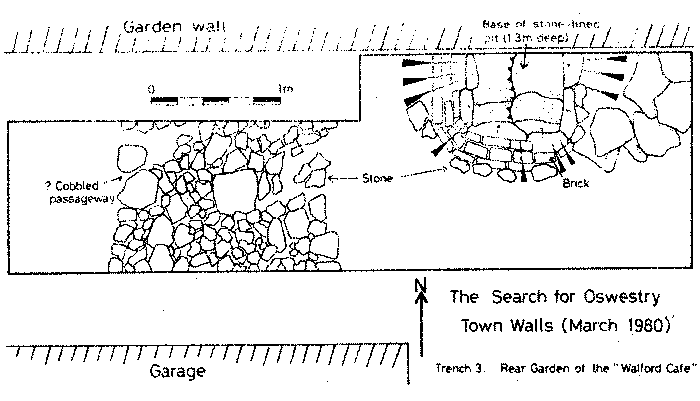
The third trench was located outside the park, in the cobbled entry to the rear garden of the 'Walford Café' (now the 'Walford Pine Shop'), Willow Street, which backed onto Welsh Walls (see comments on excavation strategy, page 25, and reported sightings, page 32). Within an area limited by the close juxtaposition of a garden wall and garage, a trench 1.2m x 5.5m was opened up (see page 38). It lay within 1m of the present footpath in Welsh Walls (SJ 28832975).
At the western end of the trench, immediately below the surface cobbles, was a 10cm band of reddish, gritty clay, which in turn covered a layer of large stones and cobbles almost 2m wide, unmortared and. resting on the natural clay, and occupying the width of the trench. No pottery was associated with this find, which, clearly not the footings of the town wall, has been interpreted as a crudely cobbled passageway.

At the eastern end of the trench a semi-circular line of hand-made bricks was traced down to its base, revealing a funnel-shaped structure lined with red clay, which led into a stone-lined and -bottomed pit, 75 cms below the level of the 'cobbled way' and full of ash and burnt debris, (it has been suggested elsewhere (page 17) that this ash, charcoal and other debris may be associated with one of the great fires that swept Oswestry in the sixteenth century).
The massive stone blocks, which showed more of the expected characteristics of a town wall, were traced down, but were discovered to be the end of a building, constructed from large stones and resting on the natural boulder clay. This is the first medieval building to come to light in Oswestry, and the pit described above appears to belong to a second phase of construction. Associated with this structure were a small number of pottery sherds and a little bone. The pottery has been identified as late medieval (l5th century) dark-green/brown lead glazed ware. The sherds, which are of coarse ware, seem to relate to wheel-made vessels, one possibly from a long-necked jug. The failure to locate the course of the town wall in this trench suggests that its line is to be found running much closer to, and probably under, the footpath and road in Welsh Walls, There was still some scope in the garden of the 'Walford Pine Shop' for further exploration. This duly took place, under the supervision of Mr. Max Glaskin on 26/27 July and 20 September 1980, but with negative results, apart from giving everyone involved some good practice in excavation techniques!


