THE SEARCH FOR OSWESTRY TOWN WALL
by DERRICK PRATT
III. RECORDED SIGHTINGS OF THE WALL
In that there are no visible remains of Oswestry's town wall and gates, the archaeologist, in the first instance, must rely heavily on the evidence afforded by the casual sighting of the foundations to recover, however approximately, the former course of the wall. However, since 1865 only twelve recorded discoveries have been made of some residual fragment of the town's medieval defences. These have been plotted (figures corresponding to numbered paragraphs below) on the composite map on page 28. The map also shows the conjectural, and frequently divergent, lines of the wall as worked out by various 'authorities' ( *70 ) over the years. It illustrates well the size of the problem facing the B.C.A.G. in their current search for the wall! Almost certainly there have been many more sightings, but they have failed to excite the interest of the local populace and, coupled with ignorance as to the nature of the finds, they have gone unreported. Unfortunately, most of the sightings have occurred in areas where the line of the wall is more or less well substantiated; none have been reported from the large negative areas such as Coney Green, where our knowledge of the route followed by the wall is skimpiest or most contradictory.
Reported sightings are referred to either in I. Watkin, Oswestry &c , or Bygones, relating to Wales and the Border Counties . Frustratingly, they are second or third hand, unaccompanied by maps or diagrams, and lack the precision and detail which would allow the line of the wall to be pinpointed with greater accuracy. Brief, verbatim details of the sightings are as follows:
- "... and in l865, while excavating for the sewage drain, near the post office here, the workmen came across some steps at a depth of ten feet below street level, and at a depth of fourteen feet to some mud that probably formed the bed of the old moat ..." ( *71 ). In all probability this was the footings of the New Gate.
- "... and afterwards when some digging was being carried out in front of Mr. Bradley's premises a block of solid masonry was exposed to view, and which it is believed formed part of the foundation of New Gate" ( *72 ). Bradley's was No. 26 Church Street, formerly, with No. 28, the 'Cross Street Vaults' and later the 'Wrexham Hotel'. Now the premises of Derwas Bros., ironmongers ( *73 ).
- The site of the Cambrian Service Garage at the junction of King Street and Beatrice Street was formerly occupied by a Wesleyan, later Methodist, church. Work on this building started in May 1870 and was completed in September 1871. "The excavation (? of the basement rooms) proved expensive, for it was found that the south wall ran in the course of the old town moat, making it necessary to go to the depth of twenty-eight feet below the ground floor line to reach a firm foundation .." ( *74 ). A pity the wording here is ambiguous. Did the south wall of the church cut the moat or ditch at an angle as it ran from a point somewhere in Richard Street? Or did the wall run parallel to the moat, in which case the line of the ditch, and therefore the wall, possibly coincides with King Street?

- Christ Church, the United Reformed church in Arthur Street, immediately adjacent to the Castle Bank, was built on the site of the old lock-up, erected in 1826 and demolished in 1871. "The old lock-up was quickly demolished, and whilst excavations were being made, some stone work - presumably a portion of the town wall - was discovered by workmen ..." ( *75 ). Again, a more explicit description could have shed light on the junction the wall made with the castle defences, and whether the wall ran off down Chapel Street or along some of the property boundaries to the rear of Willow Street.
- " The Oswestry Castle Bank Excavations . During the past week the excavations on the Castle Bank have revealed a perfect angle of what is conjectured to have been one of the rooms of the old castle. The committee have suggested that local antiquaries should inspect the place before it is again filled in. The work is being rapidly proceeded with" ( *76 ). This discovery was made during landscaping activities prior to the handing over of Castle Bank (the former motte) to the townspeople of Oswestry to mark Queen Victoria's Diamond Jubilee.
- "No, 80 Willow Street. Two cottages formerly stood upon the site of this ... About 1907 the property was acquired by the late Councillor Joseph Vaughan, and whilst preparing the foundations of the present building the excavators came across a portion of the old town walls" ( *77 ). In present day terms, No. 80 would have stood on the white line down the middle of Castle Street ! It became part of a larger building, No. 78, itself demolished for road widening (see map on page 31). Nos. 72 - 76 Willow Street, along with Nos. 2-8 Chapel Street and Nos. 51 - 77 Castle Street have been replaced by a 'temporary' car park. This particular exposure would be immediately north of, possibly adjacent to, the fragment of wall exposed at the same road junction in November 1980 (see No.12 below).
-
THE WALLS OF OSWESTRY. An Interesting Discovery
. Some building operations-at the junction of Willow Street and Castle Street,
Oswestry, have resulted in the discovery of a portion of the wall which, at one
time, surrounded the town. A block of buildings at this point is being rebuilt
by order of Mr. Joseph Vaughan, who recently acquired the property, and it was
during the pulling down of the old to make way for the new that men in the
employ of Mr. Samuel, builder, discovered portions of the wall referred to. The
wall extended practically from end to end of the space dealt with, and there
can be no doubt that it continued along Castle Street, for portions of it can
be traced in some adjoining cottages. The wall rose to a height of 8ft. above
the floor level. On one side, that facing the town, it was battered, while on
the other side it was plumb. Thus while it measured 5ft. wide at the floor
level, it was only some 3ft, at the top. The wall went down a considerable
depth below the ground level, measuring, Mr. Samuel informed one of our
representatives, something like 8ft, "and goodness knows (he added) how much
further down it went". The old wall consisted of huge blocks of stone, some of
it Sweeney rock, varying in weight from three to five hundredweight, and
mortar, and was as solid as a rock.

It may be mentioned that a few feet away from the wall, the builders came across a flight of seven steps leading from the ground floor to a kind of subterranean passage, leading towards Willow Street, further progress being blocked by a door. The passage was not explored, and the door has been covered up with brick walling. The work of reconstruction is well advanced, and up to the present, apparently, it has not occurred to anyone as fitting to replace one of the stones (suitably inscribed, to mark the position of the old wall" ( *78 ). This description obviously relates to No. 6 above. Does the reference to replacing a stone signify that the exposed section of wall was completely removed by workmen? Or only in part? If the latter it goes some way towards confirming the comments made by Mr. J.J. Williams, resident engineer for the Willow Street sewerage scheme, who, in December 1980, stated that the section of the wall exposed in his trench "is not in a straight line or of even thickness" as it ran north into Castle Street (see No.12 below). The dimensions of the wall as given above appear to relate to a complete cross-section, and would indicate a very slender structure. Such measurements conflict with the generally accepted estimates obtained from the Welsh Walls sighting in 1973 (see No. 9 below). - "... during excavations for building purposes in a garden adjoining Welsh Walls, some years ago, a portion composed of huge blocks of sandstone, with mortar which had become as hard as the stone, about six foot thick and four feet in height, was unearthed ..." ( *79 ). This may be tentatively attributed to the 1920s, but on which side of Welsh Walls was the discovery made? Possibly the east side, where outhouses, small stables etc. belonging to houses in Willow Street abut onto Welsh Walls and have seen frequent conversions to almost every possible alternative use. A thorough exploration of the rear garden of No. 55 Willow Street (see excavation report in Part IV) proved negative, and suggests that the wall at that point must underlie the road or pavement in Welsh Walls. This particular sighting, therefore, was probably made in the garden of one of Nos. 59- 65 Willow Street.
- "No sign of the Town Walls appears above ground today, but in June 1973 part of them was uncovered in excavations made for the new premises of Messrs. Mumford near the 'Golden Tankard' public house. The opportunity was taken of plotting on the 1:500 O.S. map of 1874 what was left standing of the wall. All was below the ground level of the previous building. The accompanying plan shows the line of the wall as found, and what the position of the wall would have been if it had continued on the same line towards the New Gate" ( *80 ). The actual plan which accompanied the late Mr, W. Day's record of this discovery is given on page 30" The width of the wall as communicated by Mr. Day, was 'about seven feet'. No larger scale drawings were made.
- Communication, dated 15 March 1981, by Mr, J. Pryce-Jones to the secretary of the B.C.A.G.: "Two or three years ago I was walking up Willow Street, and, at the junction of Willow Street with Welsh Walls, there was the inevitable road work. In this case, I think the hole was for gas. I looked into the hole and, at the bottom, I saw a section of the wall, quite thick, and large pieces of stone" ( *81 ). This sighting was near the kerb face outside No. 65 (corner house) Willow Street, and would appear to have been in direct line with the November 1980 exposure (see No. 12 below) on the opposite side of the road.
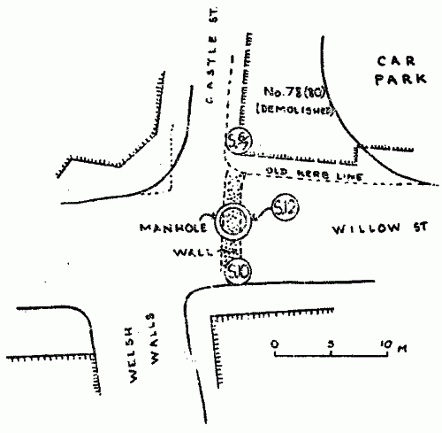
- Communicated 31 October 1980 by Mr. Ewart Francis to the secretary of the B.C.A.G. that "... the G.P.O. had unearthed large boulders on the Arundel Road/Welsh Walls junction, on the Arundel Road side. It was difficult to decide what these were as the trench was not big enough, but they were certainly large enough to have been used in the construction of the wall" ( *82 ). This trench was excavated in close juxtaposition to the suspected line of the wall. From the limited amount of information at our disposal, these large boulders may possibly represent 'tumble' from the wall.
- On 30 October 1980 the contractors for the new sewer in Willow Street broke through the foundations of the town wall at the junction of Willow Street and Castle Street. A manhole was being constructed a foot inside the white line running down the centre of Castle Street (see map on page 31). Although the B.C.A.G. were holding a watching brief, in the short space of thirty minutes the stone and mortar had been dug out and steel and timber shuttering erected along the sides of the trench prior to the pouring of concrete. It was noticed, however, that the upper layers of the stone work had already been disturbed by the laying of G.P.O. and electrical cables. The wall was visible, partial cross-section only, in the north side of the trench, and according to the resident engineer, visibly narrows and changes alignment by about 30º (see No. 7 above). The wall could not be seen in section in the south face of the trench, and had either been removed with the laying of the original Victorian sewer which lies alongside the new one, or the manhole possibly marks the point where the wall terminated at the Willow Gate ( *83 ).
Overall, the above reports make frustrating reading, and shed little light on the problem of recovering the line and dimensions of Oswestry's medieval wall. Indeed, by their very inadequacy, the records of casual sightings perhaps complicate rather than elucidate matters. This section of the report, therefore, is best terminated with a plea to owners and developers of sites along the conjectured line of the wall, that if actual physical traces are discovered, please allow members of the B.C.A.G. sufficient time to make an adequate record of the find!


